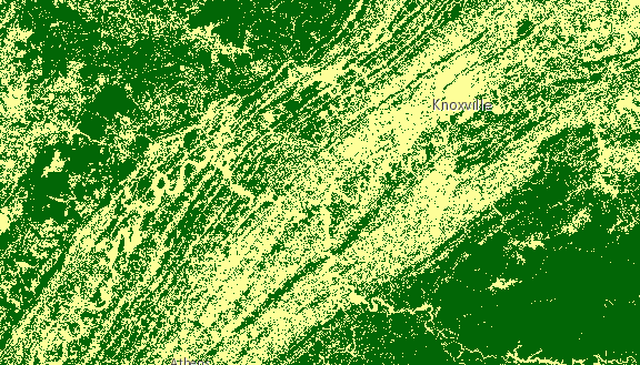
Specifies processing to be done to the image service. See raster functions for a list of functions and their arguments. The following image shows a landcover ImageryLayer rendered with two chained client-side raster functions used to reclass pixel values (Remap) and assign each pixel a new color (Colormap).
Chaining raster functions is accomplished by setting the Raster argument in the functionArguments property to another defined raster function. See example below on chaining a Remap raster function with a Colormap.
var remapRF = new RasterFunction();
remapRF.functionName = "Remap";
remapRF.functionArguments = {
  InputRanges: [-3,10,11,37], // remap pixels with values -3 to 10 to now have value of 1
  OutputValues: [1,2],        // remap pixel values from 11 to 37 to have a value of 2
  Raster: "$$"  // Apply remap to the image service
};
remapRF.outputPixelType = "u8";

var colorRF = new RasterFunction();
colorRF.functionName = "Colormap";
colorRF.functionArguments = {
  Colormap: [
    [1, 255, 0, 0],  // Symbolize pixels with value of 1 using red color
    [2, 0, 255, 0]   // Symbolize pixels with value of 2 using green color
  ],
  Raster : remapRF  // Apply Colormap to output raster from the remap rasterFunction
};

imageLayer.renderingRule = colorRF; // Set rendering rule to final raster function
Constructors
new RasterFunction(properties)
properties Object See the properties for a list of all the properties that may be passed into the constructor. |
Property Overview
| Name | Type | Summary | |
|---|---|---|---|
| String | The name of the class. more details | more details | |
| Object | The arguments for the raster function. more details | more details | |
| String | The raster function name. more details | more details | |
| String | Defines the pixel type of the output image. more details | more details | |
| Object | The variable name for the raster function. more details | more details | |
Property Details
declaredClassStringreadonly
The name of the class. The declared class name is formatted as
esri.folder.className.functionArgumentsObject
The arguments for the raster function. The structure depends on the function specified. See raster functions for a list of functions and their arguments.
Example:rasterFunction.functionArguments = { "Azimuth":215.0, "Altitude":75.0, "ZFactor":0.3 };functionNameString
The raster function name. See raster functions for a list of functions and their arguments.
Example:rasterFunction.functionName = "Stretched";outputPixelTypeString
Defines the pixel type of the output image.
Known Values: c128 | c64 | f32 | f64 | s16 | s32 | s8 | u1 | u16 | u2 | u32 | u4 | u8 | unknown
Default Value: unknownExample:rasterFunction.outputPixelType = "u8";variableNameObject
The variable name for the raster function.
Example:rasterFunction.variableName = "DEM";
Method Overview
| Name | Return Type | Summary | |
|---|---|---|---|
| * | Creates a new instance of this class and initializes it with values from a JSON object generated from a product in the ArcGIS platform. more details | more details | |
| Object | Converts an instance of this class to its ArcGIS Portal JSON representation. more details | more details | |
Method Details
fromJSON(json){*}static
Creates a new instance of this class and initializes it with values from a JSON object generated from a product in the ArcGIS platform. The object passed into the input
jsonparameter often comes from a response to a query operation in the REST API or a toJSON() method from another ArcGIS product. See the Using fromJSON() topic in the Guide for details and examples of when and how to use this function.Parameter:json ObjectA JSON representation of the instance in the ArcGIS format. See the ArcGIS REST API documentation for examples of the structure of various input JSON objects.
Returns:Type Description * Returns a new instance of this class. toJSON(){Object}
Converts an instance of this class to its ArcGIS Portal JSON representation. See the Using fromJSON() topic in the Guide for more information.
Returns:Type Description Object The ArcGIS Portal JSON representation of an instance of this class.
