When symbols have an offset from their position, it's important to still see what the real location is. This can be achieved with callouts:
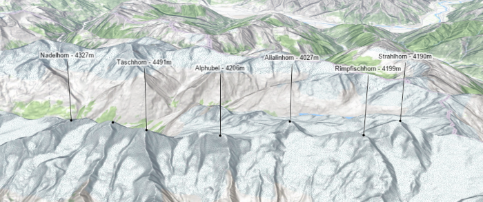
Callouts are graphics that help users understand where a label or a symbol (usually a point) is located on the map, when the symbols have an offset from their initial position.
Callout3D is the base class for classes that add a callout visualization when a PointSymbol3D or a LabelSymbol3D has an offset (for example a verticalOffset). Currently only callouts of type line are supported. See LineCallout3D.
Constructors
new Callout3D(properties)
properties Object See the properties for a list of all the properties that may be passed into the constructor. |
Property Overview
| Name | Type | Summary | |
|---|---|---|---|
| String | The name of the class. more details | more details | |
Property Details
declaredClassStringreadonly
The name of the class. The declared class name is formatted as
esri.folder.className.
Method Overview
| Name | Return Type | Summary | |
|---|---|---|---|
| Callout3D | Creates a deep clone of the callout. more details | more details | |
| * | Creates a new instance of this class and initializes it with values from a JSON object generated from a product in the ArcGIS platform. more details | more details | |
| Object | Converts an instance of this class to its ArcGIS Portal JSON representation. more details | more details | |
Method Details
clone(){Callout3D}
Creates a deep clone of the callout.
Returns:Type Description Callout3D A deep clone of the object that invoked this method. fromJSON(json){*}static
Creates a new instance of this class and initializes it with values from a JSON object generated from a product in the ArcGIS platform. The object passed into the input
jsonparameter often comes from a response to a query operation in the REST API or a toJSON() method from another ArcGIS product. See the Using fromJSON() topic in the Guide for details and examples of when and how to use this function.Parameter:json ObjectA JSON representation of the instance in the ArcGIS format. See the ArcGIS REST API documentation for examples of the structure of various input JSON objects.
Returns:Type Description * Returns a new instance of this class. toJSON(){Object}
Converts an instance of this class to its ArcGIS Portal JSON representation. See the Using fromJSON() topic in the Guide for more information.
Returns:Type Description Object The ArcGIS Portal JSON representation of an instance of this class.