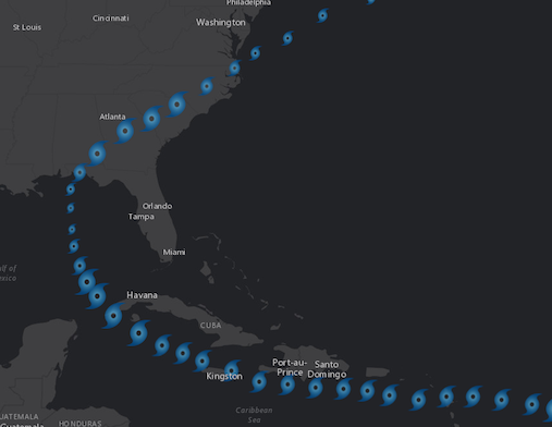
PictureMarkerSymbol renders Point graphics in either a 2D MapView or 3D SceneView using an image. A url must point to a valid image. PictureMarkerSymbols may be applied to point features in a FeatureLayer or individual graphics. The image below depicts a FeatureLayer whose point features are styled with a PictureMarkerSymbol.
To avoid CORS issues with this symbol, do one of the following:
- Use an image hosted on the same domain as the application.
- If the image is on a different domain and that server is CORS enabled, add the domain to the corsEnabledServers array.
- Install a proxy.
var symbol = new PictureMarkerSymbol({
  url: "https://webapps-cdn.esri.com/Apps/MegaMenu/img/logo.jpg",
  width: "8px",
  height: "8px"
});
Constructors
new PictureMarkerSymbol(properties)
properties Object See the properties for a list of all the properties that may be passed into the constructor. |
Property Overview
| Name | Type | Summary | |
|---|---|---|---|
| Number | The angle of the marker in degrees. more details | more details | |
| String | The name of the class. more details | more details | |
| Number | The height of the image in points. more details | more details | |
| String | For PictureMarkerSymbol the type is always | more details | |
| String | The URL to the image. more details | more details | |
| Number | The width of the image in points. more details | more details | |
| Number | The offset on the x-axis in points. more details | more details | |
| Number | The offset on the y-axis in points. more details | more details | |
Property Details
angleNumber
The angle of the marker in degrees.
Known Limitations
This property is not supported in 3D SceneViews.
Default Value: 0declaredClassStringreadonly
The name of the class. The declared class name is formatted as
esri.folder.className.The height of the image in points. This value may be autocast with a string expressing size in points or pixels (e.g.
12px).Default Value: 12Examples:// height in points symbol.height = 14;// height in pixels symbol.height = "20px";// height in points symbol.height = "14pt";typeStringreadonly
For PictureMarkerSymbol the type is always
picture-marker-symbol.urlString
The URL to the image. To avoid CORS issues with this symbol, do one of the following:
- Use an image hosted on the same domain as the application.
- If the image is on a different domain and that server is CORS enabled, add the domain to the corsEnabledServers array.
- Install a proxy.
The width of the image in points. This value may be autocast with a string expressing size in points or pixels (e.g.
12px).Default Value: 12Examples:// height in points symbol.height = 14;// height in pixels symbol.height = "20px";// height in points symbol.height = "14pt";The offset on the x-axis in points. This value may be autocast with a string expressing size in points or pixels (e.g.
12px).Known Limitations
This property is not supported in 3D SceneViews.
Default Value: 0Examples:// xoffset in points symbol.xoffset = 4;// xoffset in pixels symbol.xoffset = "2px";// xoffset in points symbol.xoffset = "4pt";The offset on the y-axis in points. This value may be autocast with a string expressing size in points or pixels (e.g.
12px).Known Limitations
This property is not supported in 3D SceneViews.
Default Value: 0Examples:// yoffset in points symbol.yoffset = 4;// yoffset in pixels symbol.yoffset = "2px";// yoffset in points symbol.yoffset = "4pt";
Method Overview
| Name | Return Type | Summary | |
|---|---|---|---|
| PictureMarkerSymbol | Creates a deep clone of the symbol. more details | more details | |
| * | Creates a new instance of this class and initializes it with values from a JSON object generated from a product in the ArcGIS platform. more details | more details | |
| Object | Converts an instance of this class to its ArcGIS Portal JSON representation. more details | more details | |
Method Details
clone(){PictureMarkerSymbol}
Creates a deep clone of the symbol.
Returns:Type Description PictureMarkerSymbol A deep clone of the object that invoked this method. Example:// Creates a deep clone of the graphic's symbol var symLyr = graphic.symbol.clone();fromJSON(json){*}static
Creates a new instance of this class and initializes it with values from a JSON object generated from a product in the ArcGIS platform. The object passed into the input
jsonparameter often comes from a response to a query operation in the REST API or a toJSON() method from another ArcGIS product. See the Using fromJSON() topic in the Guide for details and examples of when and how to use this function.Parameter:json ObjectA JSON representation of the instance in the ArcGIS format. See the ArcGIS REST API documentation for examples of the structure of various input JSON objects.
Returns:Type Description * Returns a new instance of this class. Converts an instance of this class to its ArcGIS Portal JSON representation. See the Using fromJSON() topic in the Guide for more information.
Returns:Type Description Object The ArcGIS Portal JSON representation of an instance of this class.